Satelite Map
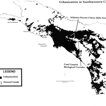
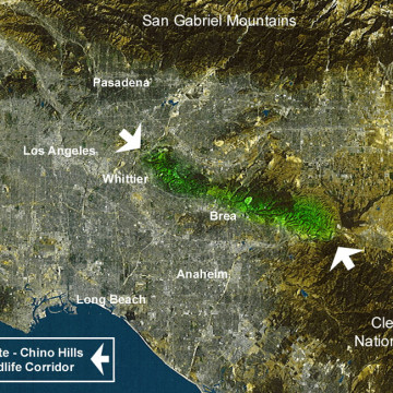
This map shows the Southern California basin from 400 miles in space. The Puente-Chino Hills Wildlife Corridor is shown in green between the two white arrows. Download this Satelite Map as a PDF.
This map shows the Southern California basin in black and white. The areas in black are urbanized with houses, roads and buildings, while the areas in white are either permanently protected or currently natural lands. Download this Gap Map as a PDF.
Scientists have designated 20 worldwide “Hot Spots.” These are places rich in species diversity, yet are threatened by imminent development. The Puente-Chino Hills Wildlife Corridor is situated in one of these Hot Spots. This Hot Spot is an area second only to tropical rain forests in both diversity of species and threat. Download the Global Hot Spots of Biodiversity Map as a PDF.
Fire scientists have been tracking wildfires in Southern California and have documented that when our coastal sage scrub and chaparral habitats burn too frequently–those habitats change. It’s called type conversion. For us, the habitats convert from our scrub/chaparral landscapes to weedy, non-native invasive grasslands. Non-native grasslands are considered flashy fuels that out compete the native plants, and are easier to ignite and spread fire faster across our habitat lands. Read the Los Angeles Times article.
Guess what? Those very high fire hazard severity zones (you know, the places most likely to burn) are where the fastest residential development is occurring in Southern California. And, interestingly–according to this new study–people in those zones are most likely to start the fires there. Let’s hope the lessons of the Freeway Complex Fire, Canyon 2 Fire, and other statewide disasters bring home the realities of how dangerous it is to build in these areas. Read the KPPC article.