View from Space

with No Comments

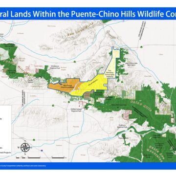
This is so cool to see our work from SPACE. East of LA’s lights the biggest dark spot (open space) is the Cleveland National Forest. If you follow that up the photo, you can see the entire Puente-Chino Hills Wildlife Corridor. Zoom in to get a closer look. If you are geographically challenged, find the biggest island (Catalina) by the rectangular-ish point (Palos Verdes) and the Puente-Chino Hills are northeast from there (aim to 2:00)

Happy 4th of July

with No Comments

Fireworks cause many wildland fires this time of year. Please know that ALL of the cities surrounding the Puente-Chino Hills Wildlife Corridor have banned fireworks. These cities include: Yorba Linda, Brea, La Habra, La Habra Heights, Whittier, Hacienda Heights, Rowland Heights, Diamond Bar, Chino Hills, and Corona. Please obey the law as the consequences can be deadly and catastrophic. Have a safe 4th of July.

Puente-Chino Hills Wildlife Corridor Map

with No Comments

Hills For Everyone updates regularly its base map for the Puente-Chino Hills Wildlife Corridor.  This map outlines the status of lands in the 31 mile long Wildlife Corridor, including existing publicly and privately protected natural lands, properties privately owned, threatened and proposed developments. Download the Puente-Chino Hills Wildlife Corridor Map as a PDF.

1 7 8 9 10 11 12 13 14

Accessibility Toolbar

Translate »