Milkweed Spotted
on July 17, 2025
with No Comments
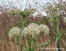
On a recent trip to Chino Hills State Park, we found milkweed. This is the first time in decades that we’ve seen this plant in the Park. We have historic photos of milkweed (photo shown left) and now this new one (photo shown right). Why is it important you ask? Milkweed is the plant that critically endangered Monarch butterflies use to lay their eggs and then when the eggs hatch, the larvae eats the milkweed. This is just one of … Read More